
Location:
McIntosh County
Sutherland Bluff Drive
Sutherland Bluff, GA 31331
GPS Coordinates:
Longitude: 81 19.489'W
Latitude: 31 33.839'N
Historical Significance:
This site was named for Lt. Patrick Sutherland because Gen. James Edward Oglethorpe recommended it in recognition for Sutherland's service at the Battle of Bloody Marsh. The bluff was a regular stop for ships sailing the inland waterway. There is evidence of ancient Indian and Spanish occupancy at the bluff.There was a shipyard laid out here during the Revolutionary War.
Historic Marker:
Marker Organization: Georgia State Historical Commission and St. Andrew's Parish Chapter, NSDAR
Marker Date: 1958
Marker Text:
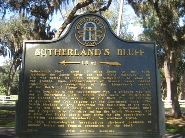
Sutherland's Bluff, about 1.5 miles South on this road, overlooks the Sapelo Riverand the Inland Waterway. The site was named for Lieut. Patrick Sutherland,to whom it was granted,upon recommendation of General James Edward Ogelthorpe, in recognition of that Lieutenant's service at the Battle of Bloody Marsh. At the beginning of the Revolutionary War,a shipyard was laid out at Sutherland's Bluff,moulds were made at Philadelphia, and live oak timbers were cut at the Bluff for the building of gunboats and four frigates for the Continental Navy. The British blockade of 1778 prevented the completion of the work.In the late 18th and early 19th centuries, Sutherland's Bluff was a regular stop for ships sailing the Inland Waterway, and a store and livery stable kept there for the convenience of outfitting passengers disembarking for overland travel. In 1954 archaeological Investigations disclosed evidence of ancient Indian and Spanish occupation of the bluff.
Historical Designations:
- State Historical Commission
Funding:
St Andrew's Parish Chapter, NSDAR is presently maintaining the marker.
Tourism:
- Open to the Public? Yes
-
Is it Family Friendly? Yes
Other Images