Map experts generally agree that the Fry/Jefferson map is the most important 18th-century map of Virginia. It was the first map to accurately depict the Blue Ridge Mountains and Colonial roads, and it also shows many of the most important plantations of the time. The map, printed in London in 1775, features original hand coloring. The scene in the lower right corner portrays the sale of tobacco, Virginia’s cash crop.
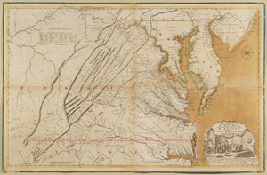
Joshua Fry and Peter Jefferson originally surveyed the area under orders of the London Board of Trade in 1750. Fry was a mathematics professor at the College of William and Mary, and Peter Jefferson (Thomas Jefferson’s father) was his assistant. They were chosen for the task because they had already completed important surveys of the Virginia Colony in the 1740s.
The DAR Museum example originally belonged to the French navy.
Volume 144, Number 5, September/October 2010, Page 7
Photography by Mark Gulezian/Quicksilver