Geography was an integral part of the early American grammar school curriculum. Books on the topic varied widely, and these examples from the DAR Museum collection show some of the favorites of 19th-century teachers and students.
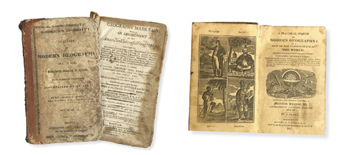
The texts shown here sought to teach geography using two methods: questions and answers, and basic descriptions. Jesse Olney’s A Practical System of Geography was the most popular 19th-century geography book. First published in 1828, it went through 98 editions, and millions of copies were sold. The DAR Museum’s copy, dated 1831, is the eighth edition. Like all of Olney’s geography textbooks, it is profusely illustrated. He revolutionized the teaching of the subject by clearly explaining geographical terms. He began with basic principles, then described all the continents starting with North America.
Jedidiah Morse wrote the next most popular book: Geography Made Easy, which he first published in 1784. It, too, enjoyed widespread popularity and went through multiple editions. The DAR Museum has the 12th edition printed in 1806. Like Olney, Morse began by describing the geography and political boundaries of the United States. Geography Made Easy gave only cursory descriptions of the rest of the world, but it was illustrated with maps, unlike Olney’s text. (Coincidentally, Morse was the father of Samuel F. B. Morse, inventor of the telegraph.)
The third popular geography book, titled Outlines of Modern Geography, was written by the Reverend Charles A. Goodrich and published in 1830. Similarly, Goodrich arranged his book into a series of questions and answers. Like Olney’s version, Goodrich’s geography is abundantly illustrated with engravings. Goodrich was also the author of many children’s books, including The Child’s History of the United States and The Universal Traveller.
The last example is the 1803 edition of A Short But Comprehensive System of Geography of the World by Nathaniel Dwight. Dwight also arranged his book in a question and answer format, but he differed from the others in that the lessons began with Europe and ended with the United States. Based on geography books written in England, Dwight’s edition found limited popularity in the fledgling United States.
Most American geographies were accompanied with a small school atlas. (The DAR Museum has an 1830 atlas that paired with Olney’s geography textbook.) Atlases consisted of a selection of maps of the continents and the United States. The maps—often hand colored to clearly show political boundaries—were connected to questions in the textbooks.
The proliferation of geography textbooks in 19th-century America demonstrates how important this subject was for teaching students of a new country more about the world around them.