
Location:
Douglas County
Palmyra Township
400 Eisenhower (East side of Junior High School)
Baldwin City KS 66006
GPS Coordinates:
Latitude: 38* 47' 10" N (38.7861964)
Longitude: 95* 10' 56" W (-95.1823595)
Historical Significance:
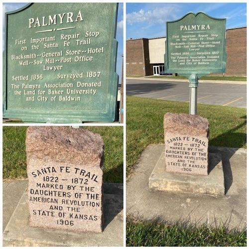
After Mexico gained its independence from Spain, the Santa Fe Trail, established in 1821, became a vital commercial route to the western territories of the United States. This trail began in Missouri and passed through Kansas, Oklahoma, and Colorado terminating in Santa Fe, New Mexico. The trail was used by traders and settlers and was instrumental in opening these states for settlement. In 1846 during the Mexican American War, it was the route used by the military to invade Mexico. It became a well-established supply route for the military to their western outposts.
The Palmyra (10) marker is one of 89 red granite Santa Fe Trail markers placed by Kansas DAR between 1906 and 1914, surveyed in 2007, and restored by 2010 with funding provided by Kansas DAR chapters. The numeric designation (10) was assigned by the Kansas Daughters as they reported the sites along the trail to the NSDAR Historic Preservation Committee. The numbering begins at the eastern most marker and increase as you travel west.
In commemoration of the 200th Anniversary of the Santa Fe Trail, Kansas Daughters added the markers to the NSDAR Historic Sites and Properties database. More than half of the 800-mile trail passes through Kansas. Along this part of the trail, you will find the town of Brooklyn, an early trading center on the trail and destroyed by Quantrill’s Raiders in 1863; continuing west, you find the water stops of Willow Springs and Flag Springs.
-
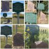
Additional 8 markers to the west (see additional images):
- (11) Brooklyn – 38 49’ 7” N 95 14’ 30” W
- (12) Willow Springs – 38 49’ 7” N 95 17’ 51” W
- (13) Globe – US 56 to Douglas Co 1029, north one mile on the west side of the road
- (14) Flag Spring – South side of US 56, one mile east of Douglas/Osage County line
- (18) Burlingame – US 56/KS 31 junction, west on Santa Fe (KS 31) to Dacotah
- (19) Dragoon Creek – North side of KS 31, 4.5 miles west of Burlingame
- (20) Wilmington – KS 31 to Santa Fe Trail Rd, south .7 mile, west .5 mile on N side of the road
- (21) Elm Creek Crossing – 38 42’ 48.688” N 96 05’ 39.233” W
Historical Designations:
- National: National Register of Historic Places
- State/County: State Historical Commission
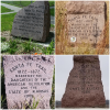
Historical Marker:
Marker Date: 1906
State of Marker Organization: Kansas
Marker Organization: Daughters of the American Revolution and the State of Kansas
Marker Text:
SANTA FE TRAIL
1822-1872
MARKED BY THE
DAUGHTERS OF THE
AMERICAN REVOLUTION
AND THE
STATE OF KANSAS
1906
Funding:
Between 1906 and 1914, Kansas DAR erected 89 Official Santa Fe Trail markers, made of red granite, at a cost of $16 each. KSDAR surveyed those 89 markers in 2007 and determined 95% needed restoration. So they were awarded a Challenge Cost Share grant from the National Park Service and contracted with stone conservators, Suhor Industries to do the restoration at an average cost of $300 per stone. Kansas chapters “adopted” a stone or two each to pay for the cost.
Physical Condition:
- Property: Preserve
Tourism:
- Open to the Public - Yes
- Family Friendly - Yes
- Hours/Days - Viewable from the Street
- Admission Fees - None
- Lodging - No
Promotional Materials Available:
Website: santafetrailresearch.com
Acknowledgement:
As all 89 markers were surveyed, beginning in 2007, and restored by 2010. DAR chapters are being asked to notify the Kansas State Historic Preservation Committee chair if they are aware of any repairs needed.
Other Images